Remote Sensing of PBL and Cloud-Surface Coupling
My research has focused on advancing our understanding of the Planetary Boundary Layer (PBL) and its crucial role in cloud-land-surface interactions, with advanced remote sensing techniques. A key aspect of this work involved the development and refinement of algorithms for improved retrieval of PBL height (PBLH) from both satellite sensors and ground-based lidar (Su et al. 2017).
Specifically, we developed a new method that accurately measures PBLH, accounting for its growth, decay, and maintenance phases (Su et al. 2020). Compared to existing methods, our approach was more consistent in capturing the PBLH's diurnal variation. Based on our method, we developed a 25-year PBLH dataset over the Southern Great Plains, now available as a Department of Energy Atmospheric Radiation Measurement (ARM) product [Dataset]. We further use this method to generate PBLH datasets across five ARM sites, showing good agreement with radiosonde measurements (Roldán et al. 2024).
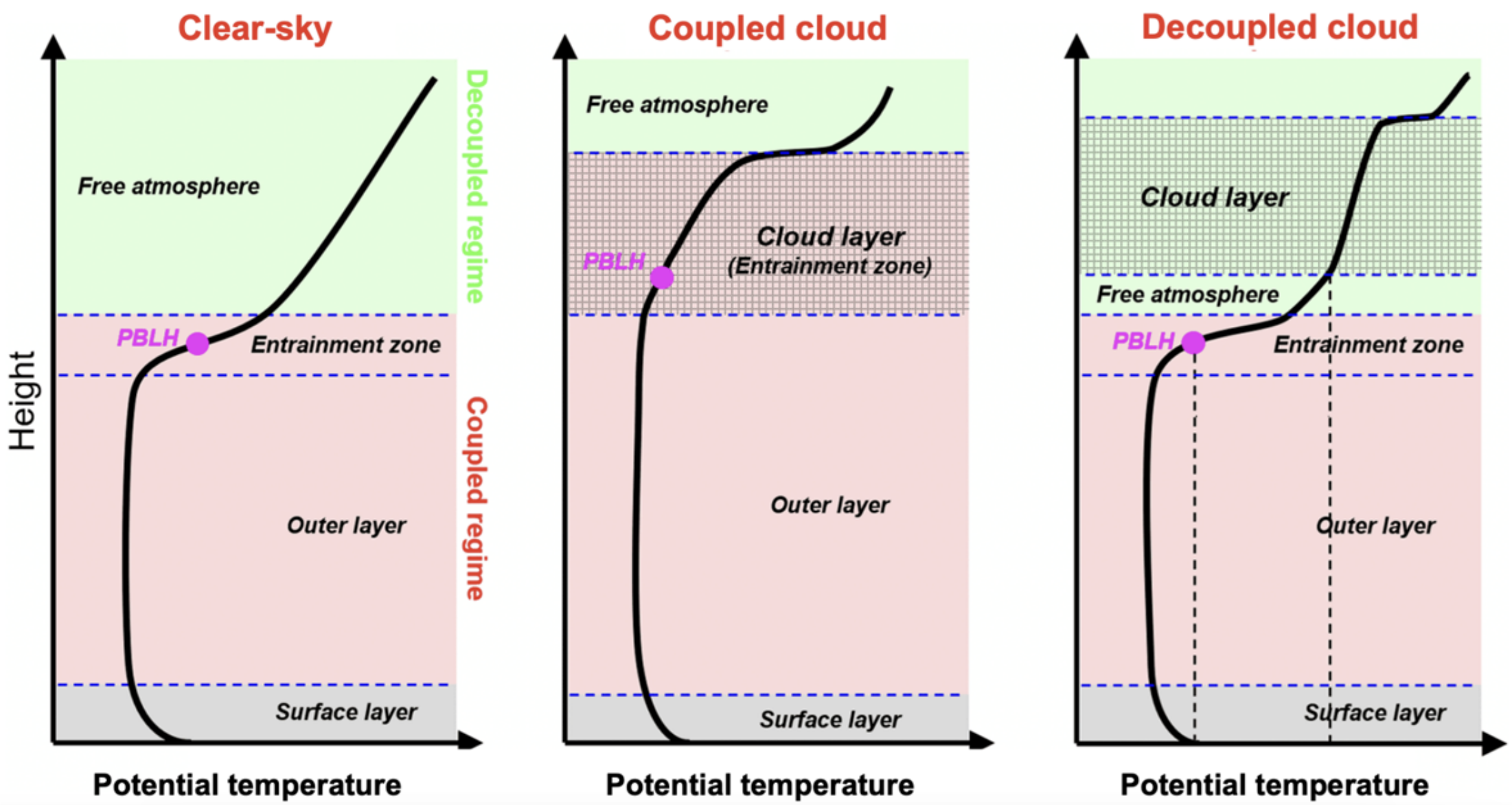
Furthermore, my studies investigate the determination of cloud-surface coupling, a phenomenon that plays a pivotal role in land-atmosphere coupling. Historical efforts to study cloud-PBL-surface coupling have been limited by a disproportionate focus on marine stratocumulus clouds. This focus has resulted in a conspicuous gap in knowledge about coupling dynamics over continental land surfaces. To address this lacuna, in our work we characterize cloud-PBL-surface coupling for low continental clouds (see Figure). This characterization details how the temperature profiles and thicknesses of different regions of the PBL differ in clear-sky conditions versus in scenarios with coupled or decoupled cloud layers. We pioneered a lidar-based technique to help determine the coupling state of these clouds and enhance available investigative tools (Su et al., 2020, 2022). Moreover, my work has led to a climatology of cloud-surface coupling over a two-decade period, highlighting the different behaviors of coupled versus decoupled clouds.
The exploration of remote sensing techniques for PBL and cloud-surface coupling contributes to unraveling the complexities of the interactions between land surface, PBL, and cloud. It lays the groundwork for investigations into the coupled surface-PBL-cloud system.

Related Papers:
- Su, T., Zheng, Y., and Li, Z., 2022. "Methodology to determine the coupling of continental clouds with surface and boundary layer height under cloudy conditions from lidar and meteorological data." Atmos. Chem. Phys. [Link] (Highlight in ARM Annual Report; ASR Highlight).
- Su, T., Li, Z., and Kahn, R., 2020. "A new method to retrieve the diurnal variability of planetary boundary layer height from lidar under different thermodynamic stability conditions." Remote Sensing of Environment. [Link].
- Su, T. et al., 2017. "An intercomparison of long-term planetary boundary layer heights retrieved from CALIPSO, ground-based lidar, and radiosonde measurements over Hong Kong." J. Geophys. Res. Atmos. [Link].
- Roldán, N.†, Su, T.*, Li, Z.*., 2024. "Refining Planetary Boundary Layer Height Retrievals from Micropulselidar at Multiple ARM Sites Around the World." Under Review.(†supervised student work, *corresponding author)
- Su, T., Li, Z., 2023. Planetary Boundary Layer Height (PBLH) over SGP from 1998 to 2023. Oak Ridge National Laboratory (ORNL), Oak Ridge, TN (United States). Atmospheric Radiation Measurement (ARM) Data Center. [Dataset]